
|
|
| DEUTSCHLAND | GERMANY |
| Bundesland: Sachsen-Anhalt | Saxony-Anhalt |
| Landkreis: Altmarkkreis Salzwedel |
map →

 Salzwedel (official name: Hansestadt Salzwedel) is situated at an elevation of 19 m in the northwest of
the Altmark region where the Salzwedeler Dumme flows into the Jeetze, about 100 km north-northwest of Saxon-Anhalt's
capital, Magdeburg. The municipality has a population of about 24,100
(2015). Salzwedel is the administrative seat of the district Altmarkkreis.
Salzwedel (official name: Hansestadt Salzwedel) is situated at an elevation of 19 m in the northwest of
the Altmark region where the Salzwedeler Dumme flows into the Jeetze, about 100 km north-northwest of Saxon-Anhalt's
capital, Magdeburg. The municipality has a population of about 24,100
(2015). Salzwedel is the administrative seat of the district Altmarkkreis.
The castle of Salzwedel in the Altmark was first documented in 1112. As part of the Margraviate of Brandenburg, the settlement was first mentioned as a town in 1233. To the northeast of the old town (Altstadt), a new town (Neustadt) began development in 1247. In the Middle Ages Salzwedel belonged to the Hanseatic League from 1263 to 1518. In 1701 it became part of the Kingdom of Prussia. In 1713, the two towns Altstadt and Neustadt became one. Salzwedel became part of the Prussian Province of Saxony in 1815 after the Napoleonic Wars. In 1870 it received a railroad connection. The official name of the city was changed into Hansestadt Salzwedel on 1 April 2008, in reference to its history as a member of the Hanseatic League.
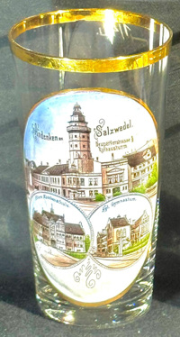
The former  Town Hall Tower [far left, no. 3259: background centre, and no. 4972,
near left: top picture] is the remainder of the town hall of Neustadt, built in 1618 in Renaissance style. The town hall
was destroyed by a large fire in 1895 and only the tower remained. The tower is open to the public and offers a splendid view on the town.
The above mentioned pictures on the two glasses are labeled "Neuperverstrasse und Rathausturm".
Town Hall Tower [far left, no. 3259: background centre, and no. 4972,
near left: top picture] is the remainder of the town hall of Neustadt, built in 1618 in Renaissance style. The town hall
was destroyed by a large fire in 1895 and only the tower remained. The tower is open to the public and offers a splendid view on the town.
The above mentioned pictures on the two glasses are labeled "Neuperverstrasse und Rathausturm".
The Höhere Mädchenschule (girls' secondary school) [bottom left picture]
was erected in 1903–1905 and opened in 1906. After many years of various uses — as a military hospital,
a House of Young Pioneers during the GDR era (1950–1990) and a school — the building stood empty for a long time.
Its structural integrity had suffered severe damage. Following a comprehensive renovation by the Salzwedel Art Foundation, it celebrated
its reopening as the Salzwedel Art Centre in 2015.
The Königliches Gymnasium (Royal Secondary School), today Friedrich-Ludwig-Jahn-Gymnasium
[bottom right picture] was founded in 1819. The new school building was constructed in 1882 and was named in 1931 after
Friedrich Ludwig Jahn, the ‘father of gymnastics’, as he had attended the Lyceum in Salzwedel for a time. The neo-Gothic brick building
is a listed building.
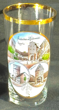
The Neuperver Tor (Neuperver Gate) [left, no. 4973: top picture] was built in 1460–1470
as the main gate of Neustadt, the 'New Town'. It is the older of the two surviving city gates and was formerly an inner gate of the
Neustadt Perver Gate.
The Karlsturm [left, no. 4973: bottom left picture, and below, no. 3788: bottom left picture]
also was part of the medieval town fortifications and is located in the southeast of the historic town centre of Salzwedel. It was built around
1370.
The Steintor (Stone Gate) [left, no. 4973: bottom right picture]
was built around 1530 and thus is the gate in the New Town

The top picture on glass no. 3788 [near left: top picture] shows the intersection
Am Lüchower Tor
The Propstei ('provost seat') [near left, no. 3788: bottom right picture]
was built as a manor house in 1578 in Renaissance style. The sandstone portal in the central star tower was added in 1754.
Until 1806 the building was extraterritorial, i.e. not part of the town of Salzwedel. In 1928 it was purchased by the
municipality. In 1929 it became the home of the collection "Altmärkischer Verein für Vaterländische
Geschichte und Industrie" ('Altmark Association for Patriotic History and Industry'), which had been founded in 1836. In
1932 it was renamed Johann-Friedrich-Danneil-Museum, honouring the German prehistorian and pedagogue Johann Friedrich
Danneil (born

The Mönchskirche (monks' church) [left, no. 3637: background]
was built in 1250 for the order of the Franciscans. The earliest document mentioning the monastery dates from 1261.
The choir and the southern side aisle were added in 1345. Further enlargements followed between 1435 and 1500. After the
Reformation, the church came in possession of the town. The last Franciscan monk died in 1552. The enclosure of the
monastery subsequently was used as a grammar school. The church was remodelled for the Protestant community between 1575
and 1581. Since 1895 the former enclosure is used as the town hall of Salzwedel. The church was closed in 1964 and
began to fall into dereliction. It was renovated and converted into a concert hall in 1984–1986.
The square depicted in the foreground is labelled
Paradeplatz
[https://de.wikipedia.org/wiki/Salzwedel, https://en.wikipedia.org/wiki/Salzwedel, https://de.wikipedia.org/wiki/Altmarkkreis_Salzwedel;
http://erlebnisland.de/sachsen-anhalt/hansestadt-salzwedel/sehenswuerdigkeiten/rathausturm-touristinfo-rathausturmplatz-salzwedel,
http://www.salzwedel.de/de/stadt/stadtgeschichte.html;
https://entdecke-salzwedel.de/lyzeum/;
https://de.wikipedia.org/wiki/Friedrich-Ludwig-Jahn-Gymnasium_Salzwedel;
https://de.wikipedia.org/wiki/Mönchskirche_(Salzwedel);
https://www.geocaching.com/geocache/GC3T4CQ_anno-1370-zu-salzwedel-karlsturm;
https://de.wikipedia.org/wiki/Johann-Friedrich-Danneil-Museum]
![[scale]](lineal.jpg)