
|
|
| DEUTSCHLAND | GERMANY |
| Bundesland: Sachsen-Anhalt | Saxony-Anhalt |
| Landkreis: Harz |
map →

Altenbrak is situated at an elevation of 304 m on the river Bode, about 20 km southwest of Halberstadt, the administrative centre of the Harz district, and about 63 km southwest of Magdeburg, the capital of Germany's state of Saxony-Anhalt. Altenbrak has a population of about 333 (2013) and is part of the municipality of Thale.
 Altenbrak was first mentioned in 1448 as a smelting site. The establishment of the village probably goes back further to 1227. However, the
last ironworks was closed in 1867. Later, tourism developed, encouraged by the sheltered situation of the village. Altenbrak was incorporated
into the municipality of Thale n 1 July 2009.
Altenbrak was first mentioned in 1448 as a smelting site. The establishment of the village probably goes back further to 1227. However, the
last ironworks was closed in 1867. Later, tourism developed, encouraged by the sheltered situation of the village. Altenbrak was incorporated
into the municipality of Thale n 1 July 2009.
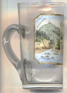
The  Schöneburg ('Schöneburg castle') [left, no. 5057: left picture] is the site of
a former castle situated on a narrow, rocky ridge encircled by the Bode river. Its location above the right bank of the river is about
one kilometre west of Altenbrak. No written records of Schöneburg Castle exist. A mention in 1654 is the only historical source. The oval
castle grounds, measuring about 30 by 80 metres, have been artificially leveled. They are protected on both sides by steep
cliffs. Two depressions in the castle grounds suggest the presence of a cellar or possibly a cistern.
Schöneburg ('Schöneburg castle') [left, no. 5057: left picture] is the site of
a former castle situated on a narrow, rocky ridge encircled by the Bode river. Its location above the right bank of the river is about
one kilometre west of Altenbrak. No written records of Schöneburg Castle exist. A mention in 1654 is the only historical source. The oval
castle grounds, measuring about 30 by 80 metres, have been artificially leveled. They are protected on both sides by steep
cliffs. Two depressions in the castle grounds suggest the presence of a cellar or possibly a cistern.
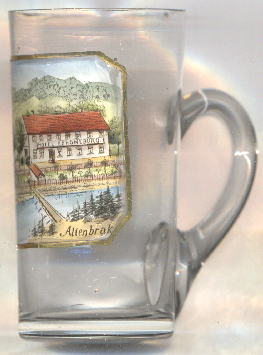
The building depicted in the right picture is identified on old postcards (dating from around 1901) as
Hotel
[https://de.wikipedia.org/wiki/Altenbrak, https://en.wikipedia.org/wiki/Altenbrak;
https://www.burgen.ausflugsziele-harz.de/ausflugsziele-sehenswertes/burg-schloss/schoeneburg-altenbrak.htm]
![[scale]](lineal.jpg)