
|
|
| DEUTSCHLAND | GERMANY |
| Bundesland: Sachsen-Anhalt | Saxony-Anhalt |
| Landkreis: Harz |
map →

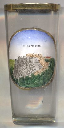 The ruins of Regenstein castle are situated on the north-western highest point of the sandstone Regenstein massif,
on a sandstone rock known as the Regenstein, which stands approximately 293 metres high and drops steeply on three sides.
The castle ruins are situated in the Harz/Saxony-Anhalt Nature Park, just under 3 km north of Blankenburg, about 11 km
southwest of Halberstadt, the administrative centre of the Harz district, and about 56 km southwest
of Magdeburg, the capital of Germany's state of Saxony-Anhalt.
The ruins of Regenstein castle are situated on the north-western highest point of the sandstone Regenstein massif,
on a sandstone rock known as the Regenstein, which stands approximately 293 metres high and drops steeply on three sides.
The castle ruins are situated in the Harz/Saxony-Anhalt Nature Park, just under 3 km north of Blankenburg, about 11 km
southwest of Halberstadt, the administrative centre of the Harz district, and about 56 km southwest
of Magdeburg, the capital of Germany's state of Saxony-Anhalt.
A count of Regenstein was first mentioned in a document dating from 1162. In the 15th century, the Regenstein counts moved to
Blankenburg Castle and Regenstein subsequently fell into disrepair and became a ruin. From 1671 the medieval castle was expanded
into a fortress by the Prussians, who were the last users of its military function. The original castle occupies only a small part
of the greater fortification. In 1677 the fort became a garrison. Even under the French, to whom the fortress had to be handed over
in September 1757, it was extended structurally. When the Prussians captured it five months later, in February 1758, they rendered
the position unusuable by blowing it up. Of the fortress only the casemate, those facilities carved out of the rock and the (now
restored) gateway remain. Today it is part of the town of Blankenburg. It is a popular tourist destination where, each year, a
knight's tournament and a garrison festival are held.
[https://de.wikipedia.org/wiki/Burg_Regenstein, https://en.wikipedia.org/wiki/Regenstein_Castle]
![[scale]](lineal.jpg)