
|
|
| DEUTSCHLAND | GERMANY |
| Bundesland: Freistaat Thüringen | Thuringia |
| Landkreis: Greiz |
map →

Ronneburg (official name Ronneburg / Thür.) is situated at an elevation of 278 m about 8 km east of the district town Gera and about 82 km east-southeast of Erfurt, the capital of Germany's State of Thuringia. The municipality has a population of about 5,000 (2024).
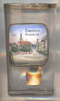 Ronneburg was mentioned for the first time in 1209 as a possession of the bailiffs of Weida. From 1244 it was in
possession of the bailiffs of Plauen. In 1304 it received the privileges of a town. In 1327 Heinrich Reuß von Plauen
signed the "Ronneburg Agreement" with other bailiffs to protect the town against the House of Wettin. Nevertheless, after the ensuing war,
Ronneburg became part of the Saxon Vogtland. In 1517 Ronneburg became the property of the Wildenfels family, in 1548 the Dukes of Saxony and
in 1826 the Duchy of Saxe-Altenburg. In 1766 the first mineral springs, which had been discovered 100 years previously,
were developed. However, the spa lost its significance before the start of uranium mining by the SDAG bismuth in 1953. During the period of the
German Democratic Republic, uranium mining was the region’s most important economic sector. Uranium mining ceased in 1990. Work began on flooding
the tunnels and reclaiming the open-cast mines. These reclamation measures were even featured as an EXPO project in 2000.
Ronneburg was mentioned for the first time in 1209 as a possession of the bailiffs of Weida. From 1244 it was in
possession of the bailiffs of Plauen. In 1304 it received the privileges of a town. In 1327 Heinrich Reuß von Plauen
signed the "Ronneburg Agreement" with other bailiffs to protect the town against the House of Wettin. Nevertheless, after the ensuing war,
Ronneburg became part of the Saxon Vogtland. In 1517 Ronneburg became the property of the Wildenfels family, in 1548 the Dukes of Saxony and
in 1826 the Duchy of Saxe-Altenburg. In 1766 the first mineral springs, which had been discovered 100 years previously,
were developed. However, the spa lost its significance before the start of uranium mining by the SDAG bismuth in 1953. During the period of the
German Democratic Republic, uranium mining was the region’s most important economic sector. Uranium mining ceased in 1990. Work began on flooding
the tunnels and reclaiming the open-cast mines. These reclamation measures were even featured as an EXPO project in 2000.
The  Town Hall [left, no. 5061: background left] was first mentioned in 1476 and was
rebuilt in 1529. Its ornate open staircase is decorated with coats of arms of crafts of those times.
Town Hall [left, no. 5061: background left] was first mentioned in 1476 and was
rebuilt in 1529. Its ornate open staircase is decorated with coats of arms of crafts of those times.
[https://de.wikipedia.org/wiki/Ronneburg_(Th%C3%BCringen), https://en.wikipedia.org/wiki/Ronneburg,_Thuringia;
https://ronneburg.de/ronneburg/allgemeine-informationen/historie/]
![[scale]](lineal.jpg)